Fishbone Forest
In the rain forest of Rondonia in western Brazil, deforestation has cut a unique fishbone pattern into the landscape that is visible from space. Beginning in the 1970s, farmers and ranchers began to clear land that branched off one main road. As new roads penetrated deeper into the forest, the continued clearing ultimately left a number of orthogonal scars running through the lush canopy. The many forest edges created by this crosshatching fragment the ecosystem and negatively impact biodiversity, even more so than logging that clear-cuts habitat. By the 2000s, connected deforested areas created open spaces now used as farmland and pastures. The visualization shows images of the rain forest captured by USGS-NASA Landsat satellites from 1975 to 2012.

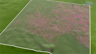
Deforestation transforms Brazil's backcountry.
Watch how this section of Rondonian rain forest, 115 miles by 106 miles, changes from 1975 to 2012.
Compare the unbroken forest of 1975 (left) to the thousands of parceled plots in 2012 (right).
In 1975, Landsat images of the rain forest showed no roads, fields or pastures.
The fishbone pattern emerged as parallel deforested tracks intersected the region's main road.
The pattern appeared more deeply etched into the forest by the mid-1990s.
By 2012, the clearings have connected with one another and created open spaces where cattle now graze.
For More Information
See NASA.gov
Credits
Please give credit for this item to:
NASA's Goddard Space Flight Center
Landsat is a joint program of USGS and NASA
-
Animators
- Trent L. Schindler (USRA)
- Alex Kekesi (Global Science and Technology, Inc.)
- Horace Mitchell (NASA/GSFC)
-
Producer
- Matthew R. Radcliff (USRA)
-
Writer
- Aries Keck (ADNET Systems, Inc.)
Release date
This page was originally published on Thursday, August 16, 2012.
This page was last updated on Wednesday, May 3, 2023 at 1:52 PM EDT.
Related
- ID: 3967
 Visualization