Deconstructing Eurasia's Wild Weather
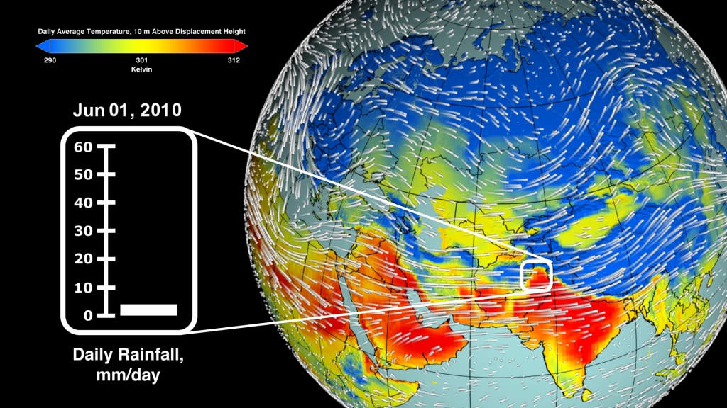
Normally the jet stream in the Northern Hemisphere carries weather fronts over Russia in four or five days. But late in the summer of 2010 conditions were anything but normal. A large-scale, stagnant region of high pressure developed and lingered over western Russia for about a month. The rare weather pattern—known to meteorologists as an Omega blocking high—split the jet stream in two, causing winds to flow around the high, an area of descending warm air, in a horseshoe-shaped pattern similar to that of the Greek letter Omega (Ω). The high blocked the normal progression of weather fronts and produced droughts and unusually warm temperatures that fueled a rash of fires near Moscow. As Russia burned, the same blocking pattern kept a low-pressure area over northern Pakistan. The cool, rising air of the low generated torrential rainfall and destructive flooding in northern Pakistan when it clashed with warmer air from the high. In the visualization below, look for the warm air from the persistent high-pressure zone over Russia (shown in yellow and red) and the cooler air from the low-pressure zone (shown in blue) just north of Pakistan.

How the same omega-shaped high sowed havoc for Russia and Pakistan
Warm air from the high over Russia (shown in red and yellow) is clearly visible from mid-July to mid-August.
Smoldering fires in the vicinity of Moscow left a heavy pall of smoke over the city for weeks.
A satellite captured this view of Manchar Lake in northern Pakistan spilling onto a large swath of land, an airport and the town of Bobak.
Manchar Lake in Pakistan, three days before the flooding seen in the previous image.
Credits
Please give credit for this item to:
NASA's Goddard Space Flight Center
Images of Smoldering Fires in the Vicinity of Moscow and of Manchar Lake courtesy of Earth Observatory, NASA/GSFC
-
Animator
- Trent L. Schindler (USRA)
-
Producer
- Adam P Voiland (Wyle Information Systems)
-
Scientists
- William K. Lau (NASA/GSFC)
- Kyu-Myong Kim (Morgan State University)
-
Writer
- Adam P Voiland (Wyle Information Systems)
Release date
This page was originally published on Thursday, September 8, 2011.
This page was last updated on Wednesday, May 3, 2023 at 1:53 PM EDT.
Papers used in this visualization
Related
- ID: 3850