Mars Gravity Map

Scientists have used small fluctuations in the orbits of three NASA spacecraft to map the gravity field of Mars.
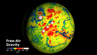
If Mars were a perfectly smooth sphere of uniform density, the gravitational pull experienced by an orbiting spacecraft would be exactly the same everywhere on the planet. But like other rocky bodies in the solar system, including Earth, Mars has both a bumpy surface and a lumpy interior. This causes the gravitational pull felt by a spacecraft to change ever so slightly as it circles Mars. For example, the pull will be a bit stronger over a mountain, and a little weaker over a canyon. Using small fluctuations in the orbital data from three NASA spacecraft—Mars Global Surveyor, Mars Odyssey, and the Mars Reconnaissance Orbiter—scientists created a new map of Mars' gravity field. The map is the most detailed to date, and provides a revealing glimpse into the hidden interior of the Red Planet. Watch the video to learn more.
Explore what the new gravity map reveals about Mars in this video.
In this gravity map of Mars, white and red are areas of higher gravity; blue indicates areas of lower gravity.
The white areas in the center of this image are higher-gravity regions produced by Mars’ massive Tharsis volcanoes.
The dark blue areas in the center of this image are low-gravity regions produced by Valles Marineris, a 2,500-mile-long Martian canyon.
For More Information
See NASA.gov
Credits
Please give credit for this item to:
NASA's Scientific Visualization Studio
-
Writers
- William Steigerwald (NASA/GSFC)
- Ernie Wright (USRA)
- None None (NASA Viz Team)
-
Scientists
- Antonio Genova (Massachusetts Institute of Technology)
- Erwan M. Mazarico (NASA/GSFC)
-
Animator
- Ernie Wright (USRA)
-
Video editor
- Dan Gallagher (USRA)
Release date
This page was originally published on Tuesday, March 22, 2016.
This page was last updated on Wednesday, May 3, 2023 at 1:48 PM EDT.
Sources
- ID: 4436
 Visualization